
User:Gazamp/Safekeeping
| {{{1}}} |
|2=
|2=

The Andes (/ˈændiːz/ AN-deez), Andes Mountains or Andean Mountain Range (Spanish: Cordillera de los Andes; Quechua: Anti) are the longest continental mountain range in the world, forming a continuous highland along the western edge of South America. The range is 8,900 km (5,530 mi) long and 200 to 700 km (124 to 435 mi) wide (widest between 18°S and 20°S latitude) and has an average height of about 4,000 m (13,123 ft). The Andes extend from South to North through seven South American countries.: Argentina, Chile, Bolivia, Peru, Ecuador, Colombia and western Venezuela.
Along their length, the Andes are split into several ranges, separated by intermediate depressions. The Andes are the location of several high plateaus—some of which host major cities such as Quito, Bogotá, Cali, Arequipa, Medellín, Bucaramanga, Sucre, Mérida, El Alto and La Paz. The Altiplano Plateau is the world's second-highest after the Tibetan Plateau. These ranges are in turn grouped into three major divisions based on climate: the Tropical Andes, the Dry Andes, and the Wet Andes. (Full article...)
Selected general articles
-
 Paquni (Aymara paqu a kind of edible herb, -ni a suffix, "the one with the paqu herbs", Hispanicized spelling Pacuni) is a 4,838-metre-high (15,873 ft) mountain in the Potosí Department of Bolivia. It is located in the Antonio Quijarro Province, Tomave Municipality, northeast of the Jatun Mundo Quri Warani volcano. (Full article...)
 -
Monte Pissis is an extinct volcano on the border of the La Rioja and Catamarca provinces in Argentina, 25 km (16 mi) to the east of the Chilean border and about 550 km (340 mi) north of Aconcagua. The mountain is the third-highest in the Western Hemisphere.
Monte Pissis is named after Pedro José Amadeo Pissis, a French geologist who worked for the Chilean government.
Due to its location in the Atacama Desert, the mountain has very dry conditions but features an extensive glacier, with crevasses, which is unique in the region. (Full article...) -
Chungará is a lake situated in the extreme north of Chile at an elevation of 4,517 metres (14,820 ft), in the Altiplano of Arica y Parinacota Region in the Lauca National Park. It has a surface area of about 21.5–22.5 square kilometres (8.3–8.7 sq mi) and has a maximum depth of about 26–40 metres (85–131 ft). It receives inflow through the Río Chungara with some minor additional inflows, and loses most of its water to evaporation; seepage into the Laguna Quta Qutani plays a minor role.
The lake formed between 8,000 and 17,000 years ago when the volcano Parinacota collapsed and the debris from the collapse dammed the Lauca River. Since then the lake has progressively grown owing to decreasing seepage. The lake is part of the Lauca National Park; a planned diversion of the lake's waters into the Azapa Valley being abandoned after a decision by the Chilean Supreme Court. (Full article...) -
Corazón (Spanish: "heart") is an inactive, eroded stratovolcano of Ecuador, situated about 30 km southwest of Quito in the western slopes of the Andes. (Full article...) -
Sierra Nevada, also known as Sierra Nevada de Lagunas Bravas, is a major ignimbrite-lava dome complex which lies in both Chile and Argentina in one of the most remote parts of the Central Andes.
Activity in the complex started in Argentina and formed two stratovolcanoes. Later, 12 or more vents formed, some with craters up to 400 metres (1,300 ft) wide. Lava flows up to 7 kilometres (4.3 mi) long with flow ridges are also found. It covers a total area of 225 km2. Radiometric dating has yielded ages of 1.7 ± 0.4 to 0.431 ± 0.012 million years ago, a lava flow from the neighbouring Azufrera Los Cuyanos volcano that is sometimes considered part of Sierra Nevada is 140,000 years old. Together with Cerro el Condor and Peinado it forms the Culampaja line, a line of volcanoes that reaches Cerro Blanco. Strong seismic attenuation is observed beneath Sierra Nevada. Hydrothermally altered rocks in Sierra Nevada may be the source of sulfate and arsenic in the Juncalito and Negro rivers, and heat sources for regional hot springs. The snowline in the area lies at 5,800 metres (19,000 ft) altitude at Cumbre del Laudo. (Full article...) -
Quilotoa (Spanish pronunciation: [kiloˈto.a]) is a water-filled crater lake and the most western volcano in the Ecuadorian Andes. The 3-kilometre (2 mi)-wide caldera was formed by the collapse of this dacite volcano following a catastrophic VEI-6 eruption about 800 years ago, which produced pyroclastic flows and lahars that reached the Pacific Ocean, and spread an airborne deposit of volcanic ash throughout the northern Andes. This last eruption followed a dormancy period of 14,000 years and is known as the 1280 Plinian eruption. The fourth (of seven) eruptive phase was phreatomagmatic, indicating that a Crater lake was already present at that time. The caldera has since accumulated a 250-metre-deep (820 ft) crater lake, which has a greenish color as a result of dissolved minerals. Fumaroles are found on the lake floor and hot springs occur on the eastern flank of the volcano.
Quilotoa is a site of growing popularity. The route to the "summit" (the small town of Quilotoa) is generally traveled by hired truck or bus from the town of Zumbahua 17 kilometres (11 mi) to the South, or more commonly by bus from Latacunga. Visitors have to pay two US dollars each to enter Quilotoa. There are a number of simple hostels in the immediate area offering services such as mules and guides. Activities include a four to five-hour hike around the caldera (whose diameter is just over 3 kilometres (2 mi)). The caldera rim is highly irregular and reaches its maximum elevations 3,810 metres (12,500 ft) to the N, 3,894 metres (12,776 ft) to the NW and 3,915 metres (12,844 ft) to the SE, at three lava domes. The 10-kilometre (6 mi) hike is sandy and steep in places and can be quite taxing, particularly if there is fog. (Full article...) -
Ancohuma or Janq'u Uma (Aymara janq'u white, uma water, "white water", also spelled Janq'uma, other spellings, Jankho Uma, Jankhouma) is the third highest mountain in Bolivia (after Sajama and Illimani). It is located in the northern section of the Cordillera Real, part of the Andes, east of Lake Titicaca. It lies just south of the slightly lower Illampu, near the town of Sorata.
Despite being higher than Illampu, Ancohuma is a gentler peak, with less local relief, and it is a somewhat easier climb. The peak was first climbed in 1919, by Rudolf Dienst and Adolf Schulze. Their route, still the easiest, climbs the southwest face, and is rated PD (not very difficult). Other routes exist on the northwest ridge and the west face. Depending on the route desired, the mountain is approached either from the west or from the northeast; each approach requires two to three days from Sorata. (Full article...) -
El Cocuy National Park is a national park located in the Andes Mountains within the nation of Colombia. Its official name is Parque Nacional Natural El Cocuy. (Full article...) -
Orestias chungarensis is a species of fish in the family Cyprinodontidae. It is endemic to Lake Chungara in Chile. (Full article...)
-

The llama (/ˈlɑːmə/; Spanish pronunciation: [ˈʎama] or [ˈʝama]) (Lama glama) is a domesticated South American camelid, widely used as a meat and pack animal by Andean cultures since the pre-Columbian era.
Llamas are social animals and live with others as a herd. Their wool is soft and contains only a small amount of lanolin. Llamas can learn simple tasks after a few repetitions. When using a pack, they can carry about 25 to 30% of their body weight for 8 to 13 km (5–8 miles). The name llama (in the past also spelled "lama" or "glama") was adopted by European settlers from native Peruvians. (Full article...) -
Simplified sketch of the present-situation along most of the Andes
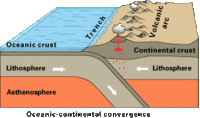
The Andean orogeny (Spanish: Orogenia andina) is an ongoing process of orogeny that began in the Early Jurassic and is responsible for the rise of the Andes mountains. The orogeny is driven by a reactivation of a long-lived subduction system along the western margin of South America. On a continental scale the Cretaceous (90 Ma) and Oligocene (30 Ma) were periods of re-arrangements in the orogeny. The details of the orogeny vary depending on the segment and the geological period considered. (Full article...) -
Chimborazo (Spanish pronunciation: [tʃimboˈɾaso] ) is an inactive stratovolcano situated in the Cordillera Occidental range of the Andes. Its last known eruption is believed to have occurred around 550 A.D. Although not the tallest mountain in the Andes or on Earth relative to sea level, its summit is the farthest point on Earth's surface from the Earth's center, due to its location along the planet's equatorial bulge. Chimborazo's height is 6,263 m (20,548 ft), well below that of Mount Everest (8,849 m).
Chimborazo is the highest mountain in Ecuador and the 39th highest peak in the entire Andes. It is a popular destination for mountaineering due to its challenging climbing routes, which involve traversing snow, ice, and rocky terrain. (Full article...) -
Huandoy (probably from Quechua wantuy, to transfer, to transpose, to carry, to carry a heavy load) or Tullparaju (possibly from Quechua tullpa rustic cooking-fire, stove, rahu snow, ice, mountain with snow) is a mountain located inside Huascarán National Park in Ancash, Peru. It is the second-tallest peak of the Cordillera Blanca section of the Andes, after Huascarán. These two peaks are rather nearby, separated only by the Llanganuco glacial valley (which contains the Llanganuco Lakes) at 3,846 m asl.
It is a snow-capped mountain with four peaks arranged in the form of a fireplace, the tallest of which is 6,395 m. The four peaks are each over 6,000 m, and are:- Huandoy (6,395 m)
- Huandoy-West (6,356 m)
- Huandoy-South (6,160 m)
- Huandoy-East (6,000 m)
-
Maipo is a stratovolcano in the Andes, lying on the border between Argentina and Chile. It is located 90 km (56 mi) south of Tupungato and about 100 km (62 mi) southeast of Santiago. It has a symmetrical, conical volcanic shape, and is among the southernmost 5,000 metre peaks in the Andes.
Maipo is located within the Diamante caldera, a feature measuring 15 km by 20 km that is about half a million years old. It rises about 1,900 m (6,230 ft) above the floor of the caldera. Immediately to the east of the peak, on the eastern side of the caldera floor, is Laguna del Diamante, a lake that formed when lava flows blocked drainage channels from the caldera in 1826. The Diamante Caldera erupted 450 cubic kilometers (108 cu mi) of tephra, 450 ka. (Full article...) -
Lake Titicaca (/tɪtɪˈkɑːkə/; Spanish: Lago Titicaca [ˈlaɣo titiˈkaka]; Quechua: Titiqaqa Qucha) is a large freshwater lake in the Andes mountains on the border of Bolivia and Peru. It is often called the highest navigable lake in the world. Titicaca is the largest lake in South America both in terms of the volume of water and surface area.
Lake Titicaca has a surface elevation of 3,812 m (12,507 ft). The "highest lake" claim is generally considered to refer to commercial craft. Numerous smaller lakes around the world are at higher elevations. For many years, the largest vessel afloat on the lake was the 2,200-ton (2,425 U.S. tons), 79 m (259 ft) SS Ollanta. Today, the largest vessel is most likely the similarly sized train barge/float Manco Capac, operated by PeruRail. (Full article...) -
Reventador is an active stratovolcano which lies in the eastern Andes of Ecuador. It lies in a remote area of the national park of the same name, which is Spanish for "exploder". Since 1541, it has erupted over 25 times, although its isolated location means that many of its eruptions have gone unreported.
The largest historical eruption occurred in 2002. During that eruption, the plume from the volcano reached a height of 17 kilometres (11 mi) and pyroclastic flows proceeded to 7 kilometres (4.3 mi) from the cone. On March 30, 2007, the mountain ejected ash to a height of about 3.2 kilometres (2.0 mi). No injuries or damage were reported. Its most recent eruption began on 27 July 2008, and it has remained in continuing eruption status (intermittent eruptive events without a break of 3 months or more) as of 15 October 2021. (Full article...) -
Telmatobius culeus, commonly known as the Titicaca water frog or Lake Titicaca frog, is a medium-large to very large and endangered species of frog in the family Telmatobiidae. It is entirely aquatic and found only in the Lake Titicaca basin, including rivers that flow into it and smaller connected lakes like Arapa, Lagunillas and Saracocha, in the Andean highlands of Bolivia and Peru. In reference to its excessive amounts of skin, it has jokingly been referred to as the Titicaca scrotum (water) frog.
It is closely related to the more widespread and semiaquatic marbled water frog (T. marmoratus), which also occurs in shallow, coastal parts of Lake Titicaca, but lacks the excessive skin and it is generally smaller (although overlapping in size with some forms of the Titicaca water frog). (Full article...) -

Coropuna is a dormant compound volcano located in the Andes mountains of southeast-central Peru. The upper reaches of Coropuna consist of several perennially snowbound conical summits, lending it the name Nevado Coropuna in Spanish. The complex extends over an area of 240 square kilometres (93 sq mi) and its highest summit reaches an altitude of 6,377 metres (20,922 ft) above sea level. This makes the Coropuna complex the third-highest of Peru. Its thick ice cap is the most extensive in Earth's tropical zone, with several outlet glaciers stretching out to lower altitudes. Below an elevation of 5,000 metres (16,000 ft), there are various vegetation belts which include trees, peat bogs, grasses and also agricultural areas and pastures.
The Coropuna complex consists of several stratovolcanoes. These are composed chiefly of ignimbrites and lava flows on a basement formed by Middle Miocene ignimbrites and lava flows. The Coropuna complex has been active for at least five million years, with the bulk of the current cone having been formed during the Quaternary. Coropuna has had two or three Holocene eruptions 2,100 ± 200 and either 1,100 ± 100 or 700 ± 200 years ago which generated lava flows, plus an additional eruption which may have taken place some 6,000 years ago. Current activity occurs exclusively in the form of hot springs. (Full article...) -
The Titicaca grebe (Rollandia microptera), also known as the Titicaca flightless grebe or short-winged grebe, is a grebe found on the altiplano of Peru and Bolivia. As its name implies, its main population occurs on Lake Titicaca. Lake Uru Uru and Poopó, the Rio Desaguadero, and small lakes that connect to Lake Titicaca in wet years, serve as "spillovers" territory. In the past, the population was larger and several of these lakes – such as Lakes Umayo and Arapa – apparently had and may still have permanent large colonies (BirdLife International 2006). It is sometimes placed in Podiceps or a monotypic genus Centropelma. Its local name is zampullín del Titicaca. (Full article...) -
Illimani is a mountain in the Khari Khari mountain range of the Bolivian Andes, about 5,030 m (16,503 ft) high. It is situated south-east of Potosí in the Potosí Department, Tomás Frías Province, Potosí Municipality. Illimani lies south-west of the mountain Uma Jalanta, north-east of Challwiri Lake and north of Illimani Lake. (Full article...)
-
Imbabura is an inactive stratovolcano in northern Ecuador. Although it has not erupted for about 7,500 years, it is not thought to be extinct. Imbabura is intermittently capped with snow and has no permanent glaciers.
Covered in volcanic ash, the slopes of Imbabura are especially fertile. In addition to cloud forests, which are found across the northern Andes to an altitude of 3000 m, the land around Imbabura is extensively farmed. Maize, sugarcane, and beans are all staple crops of the region. Cattle are also an important commodity, and much of the land on and around Imbabura, especially the high-altitude meadows above the tree line, is used for grazing. (Full article...) -
Antisana is a stratovolcano of the northern Andes, in Ecuador. It is the fourth highest volcano in Ecuador, at 5,753 metres (18,875 ft), and is located 50 kilometres (31 mi) SE of the capital city of Quito.
Antisana presents one of the most challenging technical climbs in the Ecuadorian Andes. Next to the Pichincha, Cotopaxi, Tungurahua and Chimborazo, the Antisana belongs to the five volcanic mountains that the Prussian-born explorer Alexander von Humboldt tried to climb in 1802 during his American journey. (Full article...) -
Illampu is the fourth highest mountain in Bolivia. It is located in the northern section of the Cordillera Real, part of the Andes, east of Lake Titicaca. It lies just north of the slightly higher Janq'u Uma, near the town of Sorata. Laguna Glaciar, located in the Illampu-Janq'u Uma massif, is the 17th highest lake in the world.
Despite being lower than Janq'u Uma, Illampu has a steeper peak, with more local relief, and is a somewhat harder climb. In fact it has "the hardest normal route on any of the 6,000 metre peaks in Bolivia." The easiest route, by the Southwest Ridge, is rated AD (Fairly Difficult), with snow slopes up to 65 degrees. It is accessed from a high camp on the north side of the massif. The peak was first climbed on June 7, 1928 via this route, by Hans Pfann, Alfred Horeschowsky, Hugo Hörtnagel (Germans) and Erwin Hein (Austrian). Other routes include the "German Route" on the southwest face and the South Face route, both approached from the west side of the massif. (Full article...) -

Olca is a stratovolcano on the border of Chile and Bolivia. It lies in the middle of a 15 km long ridge composed of several stratovolcanos. Cerro Minchincha lies to the west and Paruma to the east. It is also close to the pre-Holocene Cerro Paruma. It is andesitic and dacitic in composition, with lava flows extending several kilometres north of the peak. The only activity from the ridge during historical times was a flank eruption from 1865 to 1867. The exact source of this eruption is unclear. (Full article...) -


.jpg)


.jpg)


.jpg)
.jpg)


Did you know...
- ... that the 1930s Polish Andean expeditions have been credited with several first ascents and the tracing of a new route to the summit of Aconcagua, the Andes' highest peak?
Need help?
Do you have a question about Andes that you can't find the answer to?
Consider asking it at the Wikipedia reference desk.
Selected images
-
 Frederic Edwin Church, Heart of the Andes, 1859. (from Andes)
 -
 Peruvian farmers sowing maize and beans (from Andes)
 -
 Bolivian Andes (from Andes)
 -

-
 Nevado del Huila, Colombia (from Andes)
 -

-

-
 Central Andes (from Andes)
 -
 Pico Humboldt at sunset (from Andes)
 -
 View of Cuernos del Paine in Torres del Paine National Park, Chile (from Andes)
 -
 A male Andean cock-of-the-rock, a species found in humid Andean forests and the national bird of Peru (from Andes)
 -
 Aerial view of Valle Carbajal in the Tierra del Fuego. The Andes range is about 200 km (124 mi) wide throughout its length, except in the Bolivian flexure where it is about 640 kilometres (398 mi) wide. (from Andes)
 -
 Laguna de Sonso tropical dry forest in Northern Andes (from Andes)
 -

-

-
 Parinacota, Bolivia/Chile (from Andes)
 -
 Irrigating land in the Peruvian Andes (from Andes)
 -

-

-

-

-

-


.jpg)
.jpg)

.jpg)


%E2%80%93Valle_Carbajal_01.jpg)


Subcategories

- Select [►] to view subcategories
Subtopics
Associated Wikimedia
The following Wikimedia Foundation sister projects provide more on this subject:
-
 Commons
Free media repository -
 Wikibooks
Free textbooks and manuals -
 Wikidata
Free knowledge base -
 Wikinews
Free-content news -
 Wikiquote
Collection of quotations -
 Wikisource
Free-content library -
 Wikiversity
Free learning tools -
 Wiktionary
Dictionary and thesaurus
-->