
Crask of Aigas
Crask of Aigas
| |
|---|---|
 Crask of Aigas Location within the Inverness area | |
| OS grid reference | NH483421 |
| Council area | |
| Country | Scotland |
| Sovereign state | United Kingdom |
| Postcode district | IV4 7 |
| Police | Scotland |
| Fire | Scottish |
| Ambulance | Scottish |
| UK Parliament | |
| Scottish Parliament | |
Crask of Aigas (Scottish Gaelic: Àigeis Crasg, meaning "Crossing Place of Aigas"[1]) is a small hamlet in the Highland council area of Scotland. It is 4.3 miles (7 km) southwest of Beauly. The scattered hamlet of Aigas lies a short distance to the southwest.[2]
Crask of Aigas is located on a hill overlooking River Beauly; it is on the river's north side. The main street is a cul-de-sac, with the old village blacksmith's at its end.
The A831 road runs directly through the hamlet's centre, continuing all the way to Cannich and the valley of Strathglass. For this reason, Crask of Aigas has been referred to as "the gateway to the glens of the west".[3]
During the 19th century, Crask of Aigas had a village inn, and was hence a stopping point for travellers to eat and rest along with their horses.[4]
The hamlet is served by Teanassie Primary School, and a bus service to nearby Beauly.
-
 The bus shelter and road junction leading up to Crask of Aigas
 -
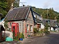 Main street in Crask of Aigas
 -
 Fields and glens looking south from Crask of Aigas


References[edit]
- ^ Taylor, Simon (2002). "PLACE-NAME SURVEY OF THE PARISHES OF KILMORACK, KILTARLITY & CONVINTH, AND KIRKHILL, INVERNESS-SHIRE" (PDF). Archived (PDF) from the original on 11 August 2011.
- ^ "Crask of Aigas". The Gazetteer for Scotland. School of GeoSciences, University of Edinburgh and The Royal Scottish Geographical Society. Retrieved 17 June 2018.
- ^ McNeish, Cameron (14 June 2012). Wilderness World of Cameron McNeish: Essays From Beyond The Black Stump. Neil Wilson Publishing. ISBN 978-1-906000-12-7.
- ^ Black's Picturesque Tourist of Scotland. Adam and Charles Black. 1851.