
File:Typhoon Utor 2013 making landfall.gif
No higher resolution available.
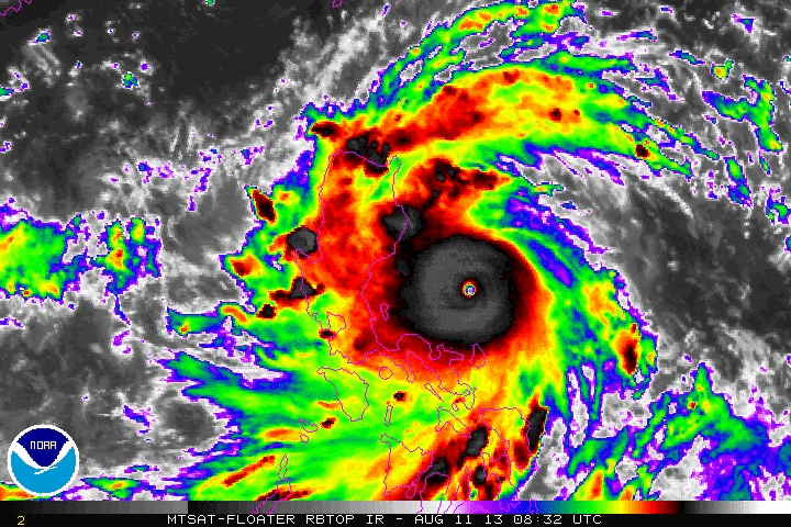
Typhoon_Utor_2013_making_landfall.gif (720 × 480 pixels, file size: 3.6 MB, MIME type: image/gif, looped, 15 frames, 3.1 s)
| This is a file from the Wikimedia Commons. Information from its description page there is shown below. Commons is a freely licensed media file repository. You can help. |
Summary
| Description |
English: Animated enhanced infrared satellite loop of Typhoon Utor (also known as Typhoon Labuyo in the Philippines) from 0832 UTC on August 11 to 2232 UTC August 11, 2013. These images show the storm at peak intensity and making landfall in the Luzon. |
| Date | |
| Source | http://www.ssd.noaa.gov/PS/TROP/floaters/ |
| Author | National Oceanic and Atmospheric Administration Satellite Services Division |
Licensing
This image is in the public domain because it contains materials that originally came from the U.S. National Oceanic and Atmospheric Administration, taken or made as part of an employee's official duties.
|
File history
Click on a date/time to view the file as it appeared at that time.
| Date/Time | Thumbnail | Dimensions | User | Comment | |
|---|---|---|---|---|---|
| current | 03:01, 12 August 2013 | | 720 × 480 (3.6 MB) | Kwlam259 | User created page with UploadWizard |
File usage
The following pages on the English Wikipedia use this file (pages on other projects are not listed):
Global file usage
The following other wikis use this file:
- Usage on tl.wikipedia.org
- Usage on zh.wikipedia.org