
File:San Francisquito Reservoir on topo v2.jpg
Size of this preview: 783 × 600 pixels. Other resolutions: 313 × 240 pixels | 627 × 480 pixels | 1,003 × 768 pixels | 1,280 × 981 pixels | 2,560 × 1,961 pixels | 3,065 × 2,348 pixels.
Original file (3,065 × 2,348 pixels, file size: 4.46 MB, MIME type: image/jpeg)
| This is a file from the Wikimedia Commons. Information from its description page there is shown below. Commons is a freely licensed media file repository. You can help. |
Summary
| Description |
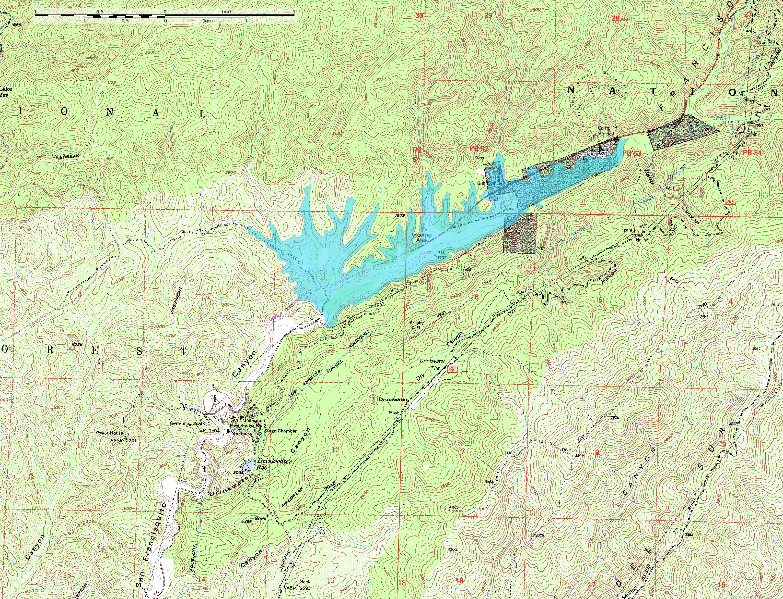
English: This map shows the approximate extent of the former San Francisquito Reservoir. The reservoir was impounded by the St. Francis Dam which failed in 1928. According to this depiction the reservoir was approximately 2.8 miles (4.5 km) long. In addition to the reservoir this map also shows the location of part of the Los Angeles Aqueduct from which it was filled; it was built as a storage stucture for the aqueduct. Also visible on the map at full size is the location of Powerhouse #2 which figures in the story of the flood created by the failure of the dam. The dark blocks indicate private inholdings in the national forest.
The reservoir extent was determined by tracing at or just below the 1840-foot elevation contour; the pool elevation was about 1835 feet when full and when the dam collapsed. The topo map includes sections of the Warm Springs Mountain 7.5" quadrangle (o34118e5) and the Green Valley quadrangle (o34118e4) from the USGS obtained as DRG files. Note: The location and orientation of the dam (at the southwest extent of the reservoir) is approximate. Additionally, the elevation data in this map is from after the breach of the dam, which caused significant erosion of the hillside at the southeast abuttment; the dam was probably a little smaller than this reconstruction depicts. |
| Date | |
| Source | Own work |
| Author | Kbh3rd |
| Other versions |
 |
| Camera location | | View this and other nearby images on: OpenStreetMap |
|---|
Licensing
I, the copyright holder of this work, hereby publish it under the following licenses:
This file is licensed under the Creative Commons Attribution-Share Alike 3.0 Unported license.
- You are free:
- to share – to copy, distribute and transmit the work
- to remix – to adapt the work
- Under the following conditions:
- attribution – You must give appropriate credit, provide a link to the license, and indicate if changes were made. You may do so in any reasonable manner, but not in any way that suggests the licensor endorses you or your use.
- share alike – If you remix, transform, or build upon the material, you must distribute your contributions under the same or compatible license as the original.

|
Permission is granted to copy, distribute and/or modify this document under the terms of the GNU Free Documentation License, Version 1.2 or any later version published by the Free Software Foundation; with no Invariant Sections, no Front-Cover Texts, and no Back-Cover Texts. A copy of the license is included in the section entitled GNU Free Documentation License. |
You may select the license of your choice.
File history
Click on a date/time to view the file as it appeared at that time.
| Date/Time | Thumbnail | Dimensions | User | Comment | |
|---|---|---|---|---|---|
| current | 04:12, 8 June 2009 | | 3,065 × 2,348 (4.46 MB) | Kbh3rd | {{Information |Description={{en|1=This map shows the approximate extent of the former San Francisquito Reservoir. The reservoir was impounded by the St. Francis Dam which failed in 1928. According to this depiction the reservoir |
File usage
The following pages on the English Wikipedia use this file (pages on other projects are not listed):
Global file usage
The following other wikis use this file:
- Usage on de.wikipedia.org
- Usage on fr.wikipedia.org
- Usage on ja.wikipedia.org