
File:EU Members Candidates 2004 2007.png

Original file (1,360 × 1,245 pixels, file size: 25 KB, MIME type: image/png)
| This is a file from the Wikimedia Commons. Information from its description page there is shown below. Commons is a freely licensed media file repository. You can help. |

|
File:EU27-2012-candidate countries map.svg is a vector version of this file. It should be used in place of this PNG file when not inferior.
File:EU Members Candidates 2004 2007.png → File:EU27-2012-candidate countries map.svg
For more information, see Help:SVG. |
 |
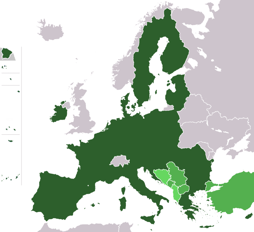
Map of the European Union with (1) member states after the 2013 enlargement, (2) candidate countries Turkey, FYR Macedonia, Montenegro, Serbia and Iceland, (3) at left (some of) the territories of France, Portugal and Spain, and (4) the potential member states (is an official EU-status, see EU-website) of the European Union (Albania, Bosnia-Herzegovina).
- France – Overseas departments (Départements d'outre-mer)
- on the North-East coast of South America:
- French Guiana
- islands in the Caribbean:
- Guadeloupe (with Saint Martin and Saint-Barthélemy)
- Martinique
- islands in the Atlantic Ocean in North America:
- Saint Pierre and Miquelon
- islands in the Indian Ocean:
- Réunion
- Mayotte - not shown
- on the North-East coast of South America:
- Portugal
- islands in the Atlantic Ocean:
- Azores
- Madeira
- islands in the Atlantic Ocean:
- Spain
- islands in the Atlantic Ocean:
- Canary Islands
- cities on the Coast of North Africa:
- Ceuta
- Melilla
- islands in the Atlantic Ocean:
Author: wiki-vr 19:38, 26 Mar 2005 (UTC)
Based on: http://en.wikipedia.org/wiki/Image:Europe_blank_map.png
| This work has been released into the public domain by its author, Wiki-vr. This applies worldwide. In some countries this may not be legally possible; if so: |
File history
Click on a date/time to view the file as it appeared at that time.
| Date/Time | Thumbnail | Dimensions | User | Comment | |
|---|---|---|---|---|---|
| current | 19:05, 10 February 2020 | | 1,360 × 1,245 (25 KB) | Hektor Absurdus | Iceland is no longer a candidate state |
| 18:44, 7 February 2020 |  | 1,360 × 1,245 (25 KB) | Hektor Absurdus | - UK | |
| 23:23, 24 January 2014 |  | 1,360 × 1,245 (24 KB) | Hektor Absurdus | + Croatia, updated candidates | |
| 08:54, 1 February 2008 |  | 1,360 × 1,245 (28 KB) | Xiong Chiamiov | optimized using optipng | |
| 09:28, 25 January 2007 |  | 1,360 × 1,245 (81 KB) | Hoshie | added Ceuta, Melilla. Sint Maarten, the SBAs, and Crown Dependencies aren't in EU. | |
| 03:21, 1 January 2007 |  | 1,360 × 1,245 (81 KB) | Cassini83 | ||
| 12:05, 29 December 2006 |  | 1,360 × 1,245 (81 KB) | Palazov~commonswiki | add Montenegro | |
| 09:35, 29 December 2006 |  | 1,360 × 1,245 (81 KB) | Palazov~commonswiki | Author: wiki-vr 19:38, 26 Mar 2005 (UTC) Based on: http://en.wikipedia.org/wiki/Image:Europe_blank_map.png {{PD-user|Wiki-vr}} Category:Maps of the European Union | |
| 20:25, 25 May 2006 |  | 1,360 × 1,245 (59 KB) | Wiki-vr | all the enlargements to come, hues of green | |
| 23:11, 23 March 2006 |  | 1,360 × 1,245 (71 KB) | Valentinian | All other borders inside the union were already removed, so removed the Danish-German one as well. Minor fixes in North Jutland (Denmark). |
File usage
Global file usage
The following other wikis use this file: