
File:Conquetes Saadiennes.PNG

Size of this preview: 525 × 600 pixels. Other resolutions: 210 × 240 pixels | 420 × 480 pixels | 683 × 780 pixels.
Original file (683 × 780 pixels, file size: 51 KB, MIME type: image/png)
| This is a file from the Wikimedia Commons. Information from its description page there is shown below. Commons is a freely licensed media file repository. You can help. |
| Description |
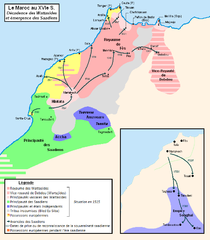
Français : Carte de l'avancée des Saadiens au Maroc au XVIe S. (1509-1591) |
| Date | (UTC) |
| Source | |
| Author |
|
| This is a retouched picture, which means that it has been digitally altered from its original version. Modifications: Ajout de l'avancée des Saadiens. The original can be viewed here: Marruecos1500-1515-Col.PNG:
|
I, the copyright holder of this work, hereby publish it under the following licenses:
This file is licensed under the Creative Commons Attribution 1.0 Generic license.
- You are free:
- to share – to copy, distribute and transmit the work
- to remix – to adapt the work
- Under the following conditions:
- attribution – You must give appropriate credit, provide a link to the license, and indicate if changes were made. You may do so in any reasonable manner, but not in any way that suggests the licensor endorses you or your use.
This file is licensed under the Creative Commons Attribution-Share Alike 3.0 Unported license.
- You are free:
- to share – to copy, distribute and transmit the work
- to remix – to adapt the work
- Under the following conditions:
- attribution – You must give appropriate credit, provide a link to the license, and indicate if changes were made. You may do so in any reasonable manner, but not in any way that suggests the licensor endorses you or your use.
- share alike – If you remix, transform, or build upon the material, you must distribute your contributions under the same or compatible license as the original.

|
Permission is granted to copy, distribute and/or modify this document under the terms of the GNU Free Documentation License, Version 1.2 or any later version published by the Free Software Foundation; with no Invariant Sections, no Front-Cover Texts, and no Back-Cover Texts. A copy of the license is included in the section entitled GNU Free Documentation License. |
You may select the license of your choice.
Original upload log
This image is a derivative work of the following images:
- File:Marruecos1500-1515-Col.PNG licensed with Cc-by-1.0, Cc-by-sa-3.0, GFDL
- 2011-03-06T01:18:36Z Omar-Toons 636x702 (37534 Bytes) Corrections mineures
- 2011-03-05T04:19:01Z Omar-Toons 636x714 (38681 Bytes) {{Information |Description ={{fr|1=Carte de la situation géopolitique du Maroc au début du XVIe S. (1500-1515) Selon : "Le Maroc dans les premières années du XVIe siècle : Tableau géographique d'après Léon L'Afric
Uploaded with derivativeFX
File history
Click on a date/time to view the file as it appeared at that time.
| Date/Time | Thumbnail | Dimensions | User | Comment | |
|---|---|---|---|---|---|
| current | 00:22, 22 March 2012 | | 683 × 780 (51 KB) | Omar-Toons | Hintata allied to Wattasids during the first quarter of the XVIth c. |
| 01:26, 6 March 2011 |  | 683 × 780 (51 KB) | Omar-Toons | {{Information |Description={{fr|1=Carte de l'avancée des Saadiens au Maroc au XVIe S. (1509-1591)}} |Source=*File:Marruecos1500-1515-Col.PNG |Date=2011-03-06 01:26 (UTC) |Author=*File:Marruecos1500-1515-Col.PNG: Omar-Toons |
File usage
The following pages on the English Wikipedia use this file (pages on other projects are not listed):
Global file usage
The following other wikis use this file:
- Usage on de.wikipedia.org
- Usage on fr.wikipedia.org
- Usage on hu.wikipedia.org
- Usage on it.wikipedia.org
- Usage on pl.wikipedia.org
- Usage on uk.wikipedia.org
- Usage on www.wikidata.org