
File:Claremont Park 1912 Map.jpg

Size of this preview: 467 × 599 pixels. Other resolutions: 187 × 240 pixels | 374 × 480 pixels | 599 × 768 pixels | 798 × 1,024 pixels | 2,468 × 3,165 pixels.
Original file (2,468 × 3,165 pixels, file size: 3.25 MB, MIME type: image/jpeg)
| This is a file from the Wikimedia Commons. Information from its description page there is shown below. Commons is a freely licensed media file repository. You can help. |
Summary
| Description |
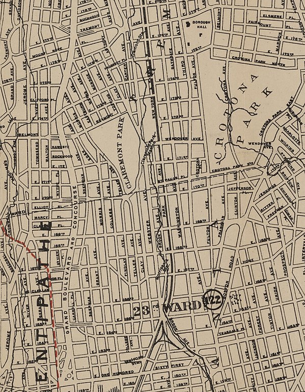
English: 1912 map showing Claremont Park and its relationship to the larger Crotona Park, 1/2 mile to the east. Visible immediately to the east of Claremont Park is Mill Brook, running approximately along the route of Webster Avenue and the eponymous Brook Avenue. Also visible to the east of the park is Claremont Park Station on the New York, New Haven and Hartford Railroad (now the New Haven line of the Metro North Railroad), at the intersection of Wendover Avenue (now Claremont Parkway) and Park Avenue. Note that Park Avenue is not named after Claremont Park; it is the continuation of Park Avenue in Manhattan. Neither the brook nor the rail station exist anymore. |
| Date | |
| Source | Crop from File:Southern part of the borough of the Bronx, from the Bronx Kills to Kingsbridge (1912).jpg |
| Author |
A.R. Ohman Map Co. (Creator) Bolton, Reginald Pelham, 1856-1942 (Creator) Ohman, August R. (Creator) Museum of the American Indian, Heye Foundation (Publisher) |
.jpg)
Licensing
This work is in the public domain in the United States because it was published (or registered with the U.S. Copyright Office) before January 1, 1929.
Public domain works must be out of copyright in both the United States and in the source country of the work in order to be hosted on the Commons. If the work is not a U.S. work, the file must have an additional copyright tag indicating the copyright status in the source country.
Note: This tag should not be used for sound recordings. |
File history
Click on a date/time to view the file as it appeared at that time.
| Date/Time | Thumbnail | Dimensions | User | Comment | |
|---|---|---|---|---|---|
| current | 14:22, 4 December 2021 | | 2,468 × 3,165 (3.25 MB) | RoySmith | Uploaded a work by A.R. Ohman Map Co. (Creator) Bolton, Reginald Pelham, 1856-1942 (Creator) Ohman, August R. (Creator) Museum of the American Indian, Heye Foundation (Publisher) from Crop from File:Southern part of the borough of the Bronx, from the Bronx Kills to Kingsbridge (1912).jpg with UploadWizard |
.jpg)
File usage
The following pages on the English Wikipedia use this file (pages on other projects are not listed):